


The questions that I receive from people often end up guiding the subjects here on the blog. The cool thing about having this contact with you is finding out the issues that matter – and also realizing that what is obvious to me may not be so obvious to you. That’s how the idea of today’s post came about! I realized that New York’s neighborhoods cause some confusion among the people who travel here. The truth is most of the tourists know how to locate in Manhattan – in Midtown and Downtown. But the rest of the city ends up being mystery for many people. So I decided to write this post to help everyone find out – both when it comes to choosing a hotel and planning the itinerary and when it comes to enjoying the days here!
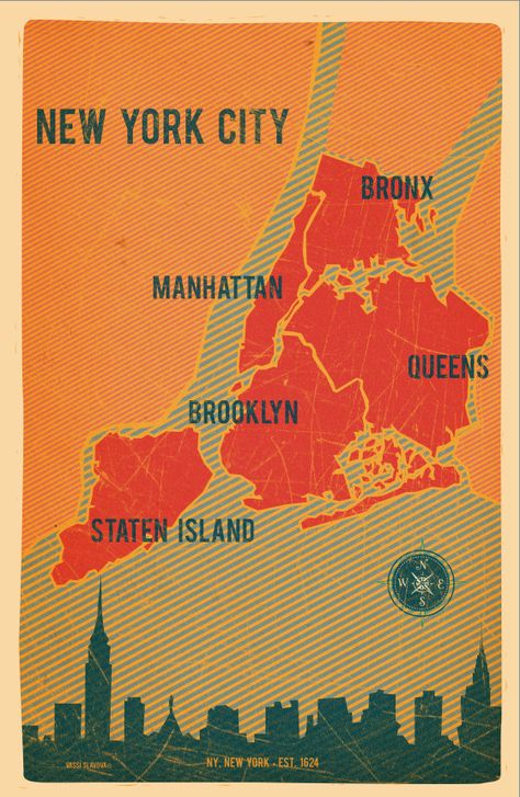
New York is the most populous city in the United States and it is divided into 5 boroughs: Manhattan, Brooklyn, Queens, The Bronx and Staten Island. The most famous is the island, Manhattan, which ends up taking 80% of the travel time of most people (or even 100%). Do you think the island is big? Compared to other districts, Manhattan is nothing …
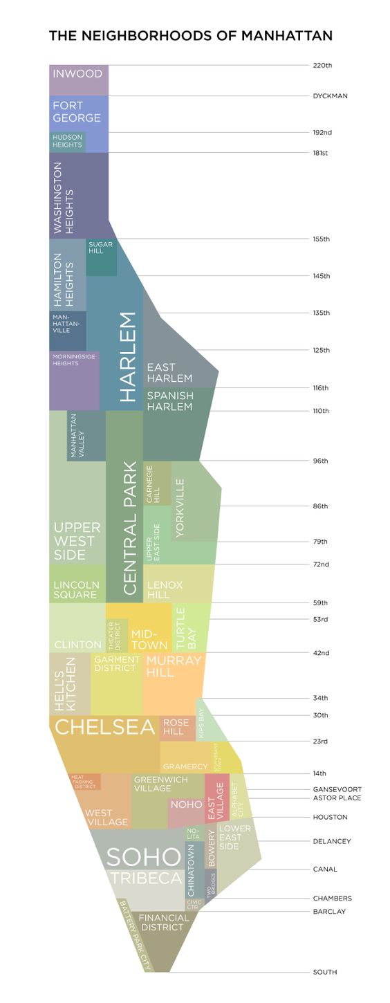
Still speaking about Manhattan, the island can be divided into three major areas: Lower Manhattan, Midtown and Upper Manhattan. Lower Manhattan is the region below Union Square (14th). Midtown is the area that runs from Union Square to 59th St (where Central Park begins). And Upper Manhattan begins on 59th street until the end of the island. The Midtown and Upper Manhattan areas are all divided into the numerical grid system, with horizontal streets and vertical avenues. This makes location much easier. Almost all avenues have numbers like First Avenue, Second Avenue, and they increase from east to west, and the streets (which are all numbered – from 1 to 220) increase from south to north. That’s why it’s so easy to walk around the island and locate quickly. For example, Bloomingdale’s is at 59th Street and Lexington Avenue. The Empire State is on Fifth Avenue, between 33 and 34th St. In the Lower Manhattan region, the system is a bit different, with streets having “normal” names. This region was colonized first, so it has a more messy location style. The grid system only starts from 14th Street.
In addition to the three major areas of Manhattan, we still have the neighborhoods in the island. On the map above, you can visualize them and get an idea of when they are located. What I realize is that a lot of people are unaware of the fact that certain neighborhoods are in the island. Harlem, for example, is in Manhattan – and is divided into three areas, inclusive.
You’ve probably heard of Broadway and its plays, right? This is a name that generates a lot of confusion … Broadway is an avenue that starts in Downtown, near Battery Park and goes to the northern tip of Manhattan. Unlike the other avenues on the island, Broadway is not linear, it will change the route as it moves up the map. At one point on the island, it is near Fifth Avenue. Already at another time, it is close to Seventh Avenue. Times Square is the spot where Broadway and Seventh Avenue meet – and it’s here in the Times Square area that the famous musicals take place. Keep this in mind … the Broadway musical theater region is Times Square and the surrounding area.
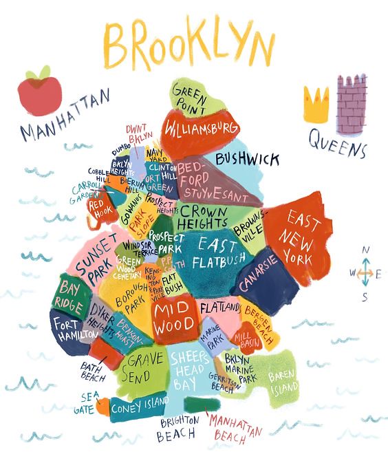
In recent years, the other boroughs of New York have gained prominence in the tourist route. Those who follow me know that I always say that the city goes far beyond Manhattan. But as I said at the beginning of the post, Manhattan is small compared to other boroughs … And if the island is “small” and most tourists invest at least 5 days to explore it, we can conclude that you can not explore the other boroughs in one afternoon, right? So when you plan your itinerary and you want to include Brooklyn, for example, you need to define which Brooklyn neighborhoods/regions/points. Are you just crossing Brooklyn Bridge and enjoying the park? Do you want to explore Williamsburg? To know the region of Coney Island? Visting Bushwick? All of these are distinct regions that are part of Brooklyn. Keep this in mind: you can not “get to know Brooklyn” in a day. On the map above, you get an idea of the location of each neighborhood.
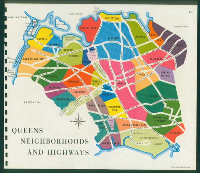
The same goes for Queens … in fact, if you thought that Brooklyn is big, check the map above! The two New York airports are located in Queens. JFK is to the south and LaGuardia to the north. Queens has become an alternative destination for many tourists who want to save money with hotels. Look on the map above for the location of the boroughs of Astoria and Long Island City – they are on the edge of the East River and, consequently, very few subway stations from Manhattan.
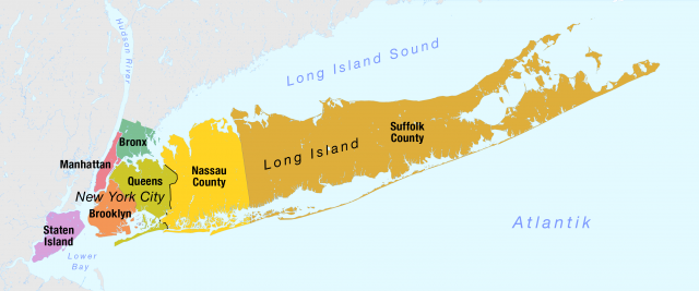
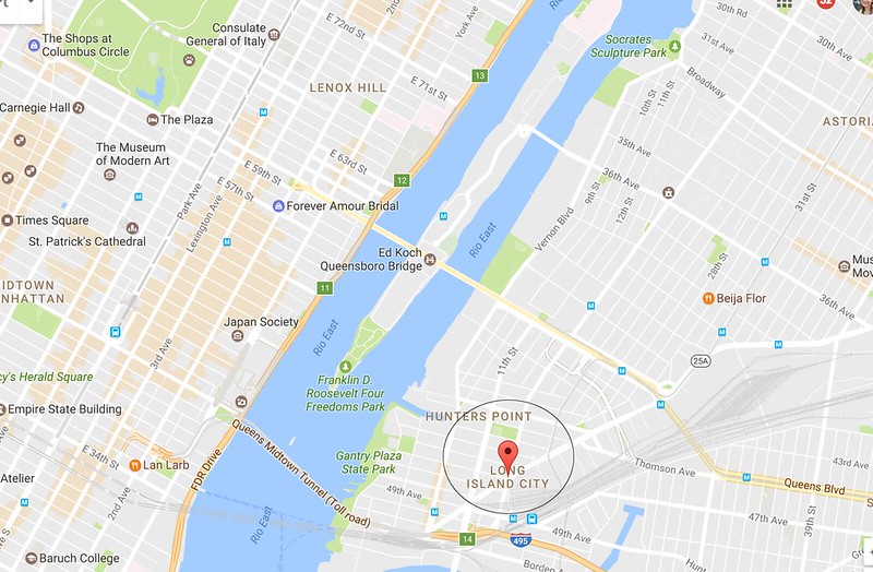
And since we’re talking about Queens, we need to talk about Long Island City. The highlighted neighborhood on the map is on the edge of the East River and the hotels in the area have been the choice of many tourists who want to save money with hotels. Depending on where you’re staying, it’s only one station from Manhattan and few minutes from Times Square. But when doing your research, do not forget that there is also the Long Island region, which you can see on the map above and is located in southeastern New York state, east of the island of Manhattan. Long Island contains four counties, two of which are boroughs (Queens and Brooklyn) in New York City, and two of which (Nassau and Suffolk) are suburban or rural. In popular usage, the term “Long Island” generally refers only to the counties of Nassau and Suffolk in order to differentiate them from New York City (The Hamptons are in Long Island). So, keep in mind: Long Island City is one thing, Long Island is something else.
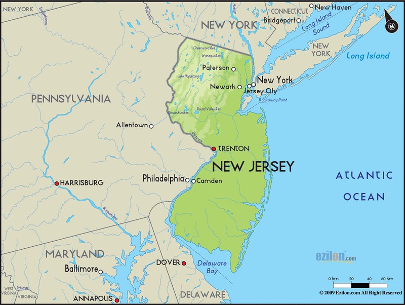
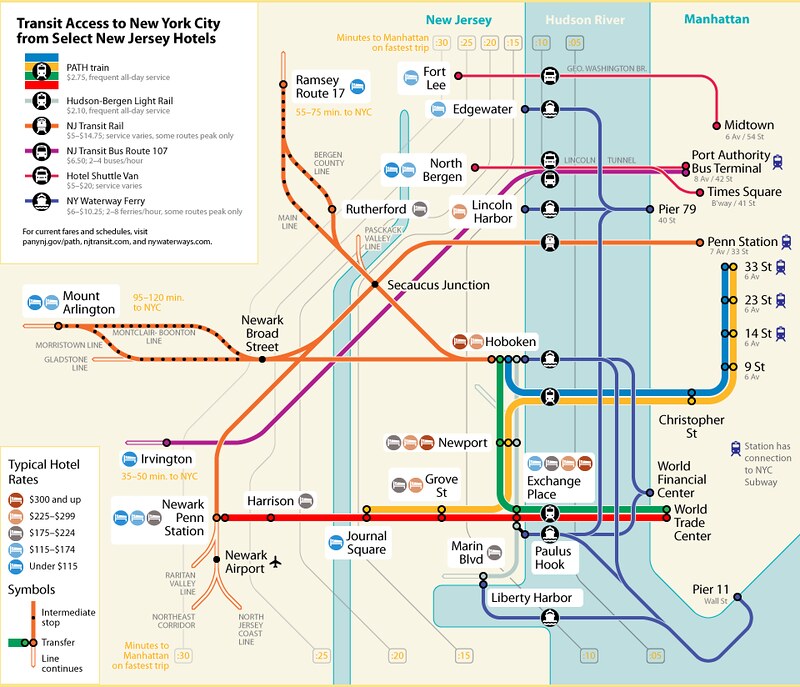
And now, we need to clarify a few points about New Jersey. The green area on the map above shows the state of New Jersey. Remember: New Jersey is a state. Newark (where it is the airport and there is a large Brazilian community), Hobokken (where is Carlos Bakery), Jersey City (where is Liberty State Park), Elizabeth (where is Jersey Gardens) are all cities of New Jersey. Some are very close to each other, some are very close to Manhattan, some have Path service (subway that goes to Manhattan), some only have buses, some rely only on trains. Are you thinking of staying in a city in New Jersey? Simulate your route on Google Maps and check the transportation options available to Manhattan. The map below shows the transportation options from some hotels in New Jersey cities to Manhattan.
I think that’s it! I hope this post has helped elucidate these location issues in New York.

Laura Peruchi is a Brazilian blogger, author, and entrepreneur. She has lived in Manhattan with her husband since 2014. Since then, she has shared on her blog varied content about the Big Apple. From travel tips, including unusual things to do, shopping tips, etiquette, restaurants, and a lot more, her blog has become a reference in Portuguese (also available in English) for anyone planning a trip to New York City.